
NexSens CB-25-SVS Wave Buoy
Features
- Measures wave height, period & direction
- Designed for drifting, tethering or mooring applications
- Integrated SeaView Systems SVS-603HR wave sensor
- Expedited repair and warranty service
- Lifetime technical support
- More
The CB-25-SVS Wave Buoy by NexSens Technology offers the latest in real-time wave observations in a compact, affordable, and easy to deploy platform. At 18” hull diameter and less than 30 lb. (13.6kg) weight, it can be used for drifting, tethering or mooring applications. The buoy accurately measures wave height, period, direction, and more using SeaView Systems’ industry-leading SVS-603HR sensor, relied upon in buoy networks by NOAA and many others throughout the world. External sensor ports with wet-mate connectors support GPS, meteorological, and water quality sensors for maximum flexibility.
The buoy is constructed of an inner core of cross-linked polyethylene foam with a tough polyurea skin. A rechargeable battery with integrated solar panels power the wave buoy continuously, and all electronics are housed in a quick-removable waterproof package with wet-mate connectors. Three 1.5” pass-through holes facilitate cable routing of underwater sensors.
Available with integrated cellular or Iridium satellite communications, the CB-25-SVS Wave Buoy sends data in real-time to the cloud-based WQData LIVE datacenter. In the Basic tier, this free service allows users to securely access and analyze data, as well as share data through an auto-report. Subscription-based tiers of WQData LIVE are also available for generating custom alarms, exporting data through an API or custom NDBC/GLOS formats, and providing a publicly-accessible version of the project website.
- Wave Sensor: SeaView Systems SVS-603HRi
- Available Wave Parameters: Significant wave height, dominant period, wave direction, mean wave direction and more
- Range: Wave Height: 0.2-20m; Wave Period: 1.5-20 seconds; Wave Direction: 0-360°
- Resolution: Wave Height: 0.001m; Wave Period: 0.001 seconds; Wave Direction: 0.001°
- Accuracy: Wave Height: +/- 0.5cm; Wave Period: <1%; Wave Direction: +/-2°
- Diagnostic Sensors: Internal temperature (-40C to 85C, 0.1C resolution, ±0.3C accuracy); Humidity (0% to 100%, 0.1% resolution, ±4% accuracy from 5 to 95% RH & -20 to 70C); Battery voltage
- Optional Water Sensors: Surface temperature, single-parameter sensors, multi-parameter sondes
- Optional Atmospheric Sensors: Single and multi-parameter weather sensors
- Optional Position Sensor: Marine GNSS receiver or standalone asset tracking device
- Sensor Interfaces: SDI-12, RS-232 (2 channels), RS-485
- Sensor Ports: (2) External sensor ports, expandable using splitters
- Battery: 12 VDC sealed lead acid (SLA) battery, 6.0 A-Hr
- Solar Power: (3) 4-watt 12 VDC solar panels
- Serial Interface: Direct RS-485 via USB adapter (for setup)
- Wi-Fi Interface: 802.11b/g/n (for setup)
- Cellular: 2G/3G, 4G LTE (North America) & CAT-M1/NB2 LTE
- Iridium Satellite: Short Burst Data (SBD) 1616 MHz to 1626.5 MHz
- Cloud Datacenter: WQData LIVE web portal with auto data export to NDBC, GLOS, and others (configurable on web portal)
- Data Logging: 256MB microSD card (expandable up to 32GB)
- Hull Dimensions: 18” (45.72cm) outside diameter; 11” (27.94cm) tall
- Tower Dimensions: 8” (20.32cm) tall, triangular
- Center Hole Dimension: 5.5" (13.97cm) inside diameter
- Weight: 30 lbs. (13.61 kg)
- Net Buoyancy: 25 lbs. (11.34 kg)
- Hull Material: Cross-linked polyethylene foam with polyurea coating & stainless steel deck
- Hardware Material: 316 stainless steel
- Mooring Attachments: (4) 3/8” eye nuts
- Operating Temperature: -20C to 70°C
- Warranty: 12 months. See terms at nexsens.com/support/warranty
- Place of Manufacture: Ohio & Michigan, USA
- Field Verification: Tested and verified by LimnoTech, Ann Arbor, MI
Select Options


In The News

Applied Research and Innovative Solutions: Creating CHNGES at Western Kentucky University
Long-standing environmental monitoring programs have the power to support a large number of research initiatives and policy changes—however, actually starting these networks can prove challenging. Not only is starting the program difficult, but keeping things operational for decades to come has also been challenging for environmental professionals hoping to make an impact with applied research. Jason Polk, Professor of Environmental Geoscience and Director of the Center for Human GeoEnvironmental Studies (CHNGES) at Western Kentucky University, is all too familiar with this process.
Read More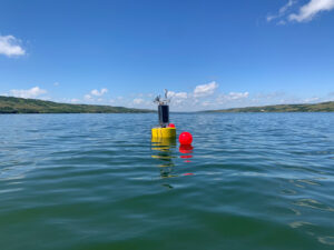
Combating Water Insecurity in Saskatchewan with Real-Time Data
The prairies of Saskatchewan can be described as one of the least water-secure parts of Canada, making water quality monitoring essential for informed resource management in a region already facing water insecurity. While natural physical properties worsen some of the poor water quality conditions in the region, others are connected to land use. Having grown up spending summers on the shores of Lake Huron, Helen Baulch, an associate professor at the School of Environment and Sustainability at the University of Saskatchewan , has always been dedicated to the protection of water resources. Looking back fondly at her childhood playing along the shore, Baulch also recalls the invasion of quagga mussels during her teenage years and watching the lake change as a result.
Read More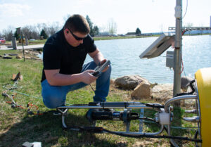
Seametrics Turbo Turbidity Logger: Boost your Turbidity Monitoring
The Seametrics Turbo Turbidity Logger is a self-cleaning turbidity sensor capable of internally logging over 260,000 data records. The sensor enables researchers, compliance officers, and contractors to monitor turbidity in various applications, from construction and dredging sites to wastewater effluent. Due to its narrow width, this device can be deployed in a range of areas, from small well spaces to rivers and streams. The stainless steel housing and built-in wiper allow the sensor to withstand long-term deployments and reduce the need for maintenance trips. The logger accurately records temperature and turbidity up to a depth of 50 meters.
Read More