
NexSens WQData LIVE Web Datacenter
Features
- 2-way communication with remote systems
- Interactive ESRI Leaflet map interface
- View & download tabular and graphical data
- Expedited repair and warranty service
- Lifetime technical support
- More
WQData LIVE is a web-based project management service that allows users 24/7 instant access to data collected from remote telemetry systems. Users with NexSens G2, X2 and V2 platforms have the ability to configure and update systems remotely via Wi-Fi, Ethernet, cellular or satellite telemetry. All projects are password-protected with multi-level access. Administrators have full access for remote communication and project modification, while collaborators are limited to viewing and exporting data.
The online database offers the ability to view live readings, configure alerts to notify project personnel when data values exceed threshold limits, export data and more. The project dashboard includes a ESRI Leaflet map view showing all project sites on a map with zoom, scroll and drag capability. The bottom of the dashboard includes a project overview, data disclaimer and project photo. For projects with multiple locations, each site within a project shows the data loggers connected along with a site photo in a convenient viewing pane.
Clicking on any site within a project displays the most recent data values alongside a graph depicting a day, week, month or year of data. Within each parameter, users can register to receive alerts via email based on a high or low threshold. A rich set of meta data and diagnostic data specific to each site is displayed at the bottom for troubleshooting sensor or data logger issues. With this rich set of tools, WQData LIVE simplifies the task of managing an environmental monitoring project.
Select Options


In The News

Applied Research and Innovative Solutions: Creating CHNGES at Western Kentucky University
Long-standing environmental monitoring programs have the power to support a large number of research initiatives and policy changes—however, actually starting these networks can prove challenging. Not only is starting the program difficult, but keeping things operational for decades to come has also been challenging for environmental professionals hoping to make an impact with applied research. Jason Polk, Professor of Environmental Geoscience and Director of the Center for Human GeoEnvironmental Studies (CHNGES) at Western Kentucky University, is all too familiar with this process.
Read More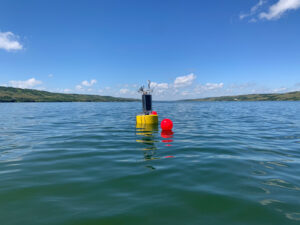
Combating Water Insecurity in Saskatchewan with Real-Time Data
The prairies of Saskatchewan can be described as one of the least water-secure parts of Canada, making water quality monitoring essential for informed resource management in a region already facing water insecurity. While natural physical properties worsen some of the poor water quality conditions in the region, others are connected to land use. Having grown up spending summers on the shores of Lake Huron, Helen Baulch, an associate professor at the School of Environment and Sustainability at the University of Saskatchewan , has always been dedicated to the protection of water resources. Looking back fondly at her childhood playing along the shore, Baulch also recalls the invasion of quagga mussels during her teenage years and watching the lake change as a result.
Read More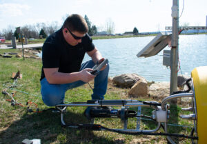
Seametrics Turbo Turbidity Logger: Boost your Turbidity Monitoring
The Seametrics Turbo Turbidity Logger is a self-cleaning turbidity sensor capable of internally logging over 260,000 data records. The sensor enables researchers, compliance officers, and contractors to monitor turbidity in various applications, from construction and dredging sites to wastewater effluent. Due to its narrow width, this device can be deployed in a range of areas, from small well spaces to rivers and streams. The stainless steel housing and built-in wiper allow the sensor to withstand long-term deployments and reduce the need for maintenance trips. The logger accurately records temperature and turbidity up to a depth of 50 meters.
Read More